
There are territories that preserve memories under layers of earth, silence and modern cultivations. Irpinia is one of these. For years the route of the Appian Waythe Regina viarum recently recognized as a World Heritage Site, has remained in this area little more than a hypothesis, a line imagined on scholars’ maps and almost invisible on the real ground. Today, thanks to technology, that line takes shape again and with it an entire forgotten Roman city re-emerges.
Drones, thermal sensors and advanced geophysical investigations brought it to light – without yet digging a single centimeter of earth. The result is surprising: in the territory of Flumeri, in the province of Avellino, the site of Fioccoglia clearly reveals the structure of an organised, monumental, strategic Roman urban centre. A place that some scholars identify with ancient Aemilii Forumactive between the 2nd and 1st centuries BC, at the height of the political and social transformations of the Roman Republic.
The discovery is the result of a research campaign conducted by the University of Salento, in collaboration with the Superintendency of Archaeology, Fine Arts and Landscape for the provinces of Salerno and Avellino and with the municipal administration of Flumeri. Coordinating the work is Professor Giuseppe Ceraudo, who has been involved for years in the reconstruction of the Roman road system along the Appia and Traiana.
A city that re-emerges without digging
The most fascinating part of this discovery concerns the method. In an era in which there is increasingly talk of landscape protection and sustainability even in scientific research, archeology is changing its skin. In Fioccaglia we didn’t start with shovels and picks, but with tools capable of “reading” the subsoil.
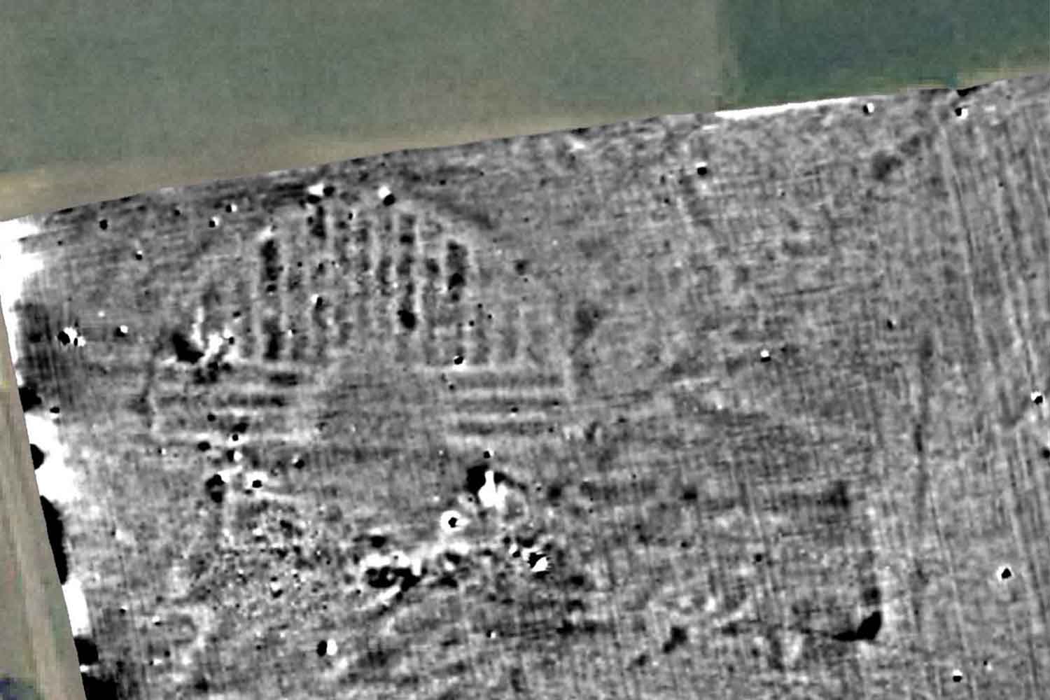
The investigations combined magnetometry, ground penetrating radar and surveys with drones equipped with thermal and multispectral sensors. Basically, an x-ray of the ground. Buried structures alter vegetation growth and the magnetic composition of the soil; sensors intercept these differences, returning detailed maps of what lies beneath the surface.
This is how road axes, public buildings and monumental spaces emerged. Without invasive excavations, with significant savings in economic and energy resources, and with minimal impact on the surrounding environment. A concrete example of how innovation and protection can proceed together.
The data becomes even more relevant if we consider that in Irpinia the route of the Via Appia is almost completely lost up to Benevento. Today we know just a small part of the route in this area, while in Basilicata and Puglia the route is more easily reconstructed up to the port of Brindisi. Fioccaglia’s discovery therefore becomes a fundamental piece in recomposing the mosaic.
Forum, theater and orthogonal streets: the monumental face of Fioccaglia
The images returned from the analyzes clearly show a orthogonal urban layouttypical of newly founded Roman cities. The road axes intersect regularly, delimiting large, planned blocks. It is the sign of conscious planning, of a city designed to last.
Among the most significant structures identified, the Holethe civil and commercial heart of the settlement. The vast central square and the perimeter of the public buildings that overlooked it were outlined. Next to the Forum appears another discovery destined to change the perception of the site: a medium sized theatrecapable of hosting around seven thousand spectators.
A theater implies shows, assemblies, social life. It implies a living community, integrated into Roman cultural models. We are not faced with a simple village passing through the consular road, but with a structured urban centre, with significant ambitions and public functions.
The site was already known from previous excavation campaigns in the 1980s, which had brought to light a paved decumanus and a luxury domus decorated in “early Pompeian style”. The new investigations expand that photograph, confirming that Fioccaglia owned public and private buildings of a certain level.
Its position along the Appia and the probable connection with a consular branch commissioned in 126 BC by the consul Marco Emilio Lepido, the so-called Via Aemilia in Hirpinis, explain the strategic role of the area in the network of connections in southern Italy.
A key piece to understand the Romanization of the hinterland
This discovery is not just an archaeological event. It is an important step in understanding the romanization of the Campania hinterland between the 2nd and 1st centuries BC, a process that profoundly transformed landscapes, economies and local identities.
The urban organization, the monumentality of the public structures, the presence of a theater and a forum tell of the integration of this territory in the Roman political and economic system. They also tell the story of the ability of local communities to adapt, transform and dialogue with central power.
The results of the research will be presented on February 27th in Lecce during a public conference promoted by the Department of Salento Studies in agreement with the Cnr. In the summer of 2026, a new excavation campaign will begin which aims to bring the entire city to light.
Under the cultivated fields of Irpinia, therefore, not only memory sleeps. A city is sleeping that is once again visible thanks to science, reminding us that the past has never really disappeared: it is just waiting for the right tools to tell its story again.