
The landslide that hit Niscemi in January is not an isolated episode nor a phenomenon that can be “solved” with some engineering intervention. This is stated in black and white in the new technical-scientific report from the Center for Civil Protection of the University of Florence, over 150 pages of geological analyses, satellite surveys and field inspections. The conclusion is clear: definitive stabilization of the slope is, given the state of knowledge, unrealistic.
The document, drawn up on behalf of the National Department of Civil Protection after the events of January 2026, describes a complex and ancient landslide system, destined to evolve over time. The most recent event in fact represents a new phase of reactivation of a disruption already documented in the past, with significant precedents in 1790 and 1997.
#Niscemi (CL), landslide on SP 10: 48 hours ago #firefighters engaged in monitoring operations in the area and in supporting the population for the recovery of goods from evacuated homes. In the clip the flyover of the Drago 156 helicopter (#27January 11.30am) pic.twitter.com/0XCcsJhFec
— Fire Brigade (@vigilidelfuoco) January 27, 2026
A landslide system that has been evolving for centuries
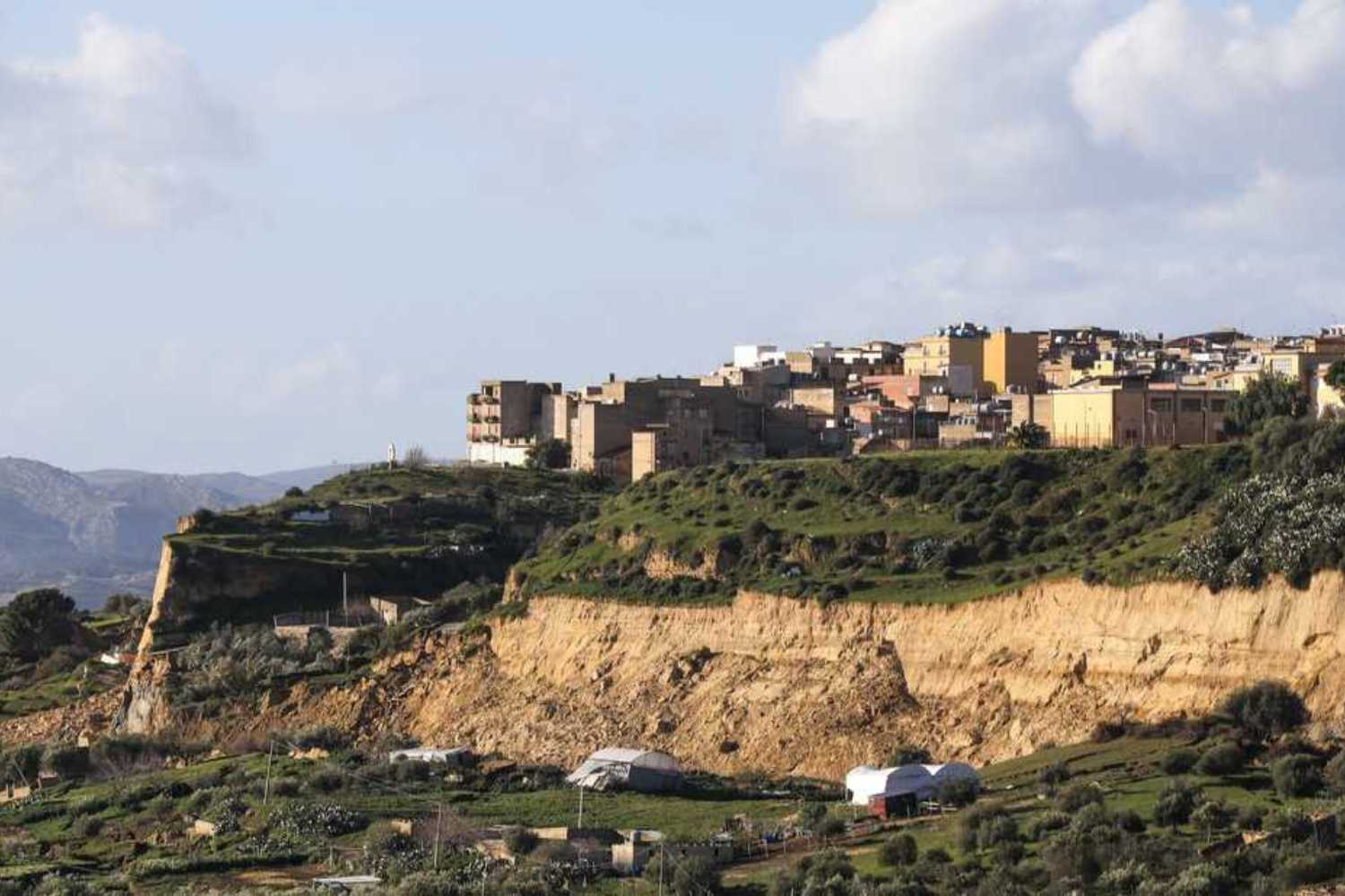
Expert analyzes indicate that the Niscemi landslide is part of a long-term geological dynamic. The town stands on permeable sandy-arenaceous soils resting on much weaker and more impermeable clay layers: a combination that favors the development of deep and unstable sliding surfaces.
In January the phenomenon manifested itself in two main phases, between the 15th and 16th and then between the 25th and 26th of the month, causing the collapse of some infrastructures and the precautionary evacuation of hundreds of people. In total, between the red zone and surrounding areas, around 1,500 residents were involved in the security measures.
According to the report, the inhabited center today appears “substantially stable”, but the main slope that delimits the town could retreat tens of meters further, especially in the event of new heavy rains. This means that other buildings and sections of road could be affected over time.
Don’t eliminate the landslide, but manage the risk
The most significant part of the document concerns the future strategy. Experts are explicit: attempting to block the entire system with extensive structural works is not a realistic solution.
The path indicated is another: adaptive risk management. In other words, learning to live with the phenomenon by progressively reducing the population’s exposure.
Among the recommended actions are the strengthening of monitoring with geotechnical and satellite instruments, the control of surface and groundwater, the constant updating of exclusion zones and, where necessary, the relocation of the most exposed buildings and infrastructures.
A key role will be played by observation technologies: inclinometers, piezometers and GNSS networks, supported by satellite radar interferometry, today allow us to identify even millimetric movements of the ground and to build early warning systems.
The debate that rekindles Muos
Meanwhile, the activists of the No Muos movement are also reigniting tension in the area. In recent days they have released a video that appears to show small landslides near gate 3 of the NRTF base in Niscemi, where the ground station of the US military satellite system is located.
According to the committees, any movements of the ground could influence the structure of the large dishes of the base. There is currently no technical confirmation of operational problems, but activists are calling for greater transparency on hydrogeological monitoring and site conditions.
The issue is part of an already delicate context: the base is located within the Sughereta di Niscemi, a natural area protected for years at the center of environmental and political protests.
Plan for the future
The scientific report leaves no room for illusions: the landslide will continue to evolve. But precisely for this reason, experts explain, it is essential to change perspective.
Security does not come from the idea of ”stopping” nature, but from territorial planning capable of adapting to phenomena that have geological timescales much longer than those of politics and urban planning.
For Niscemi, the challenge today is all here: transforming an emergency into a prevention laboratory, where continuous monitoring, data transparency and population involvement become concrete tools for coexistence with risk.