
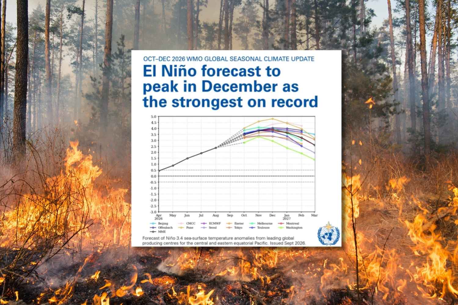
The El Niño climate phenomenon is intensifying rapidly and could become one of the most powerful of the last 75 years. The World Meteorological Organization (WMO), the United Nations agency that monitors the global climate, has raised the alarm. According to the latest forecasts, the phenomenon will reach its peak in December 2026 and will continue to influence the planet’s climate until at least February 2027, increasing the risk of extreme temperatures, droughts, fires and floods. The consequences, however, are already concrete and dramatic. For example, in Indonesia, where large areas of Borneo are already grappling with devastating fires and severe water shortages, the effects of the climatic conditions associated with El Niño are being felt. And the smoke from the fires has now reached several neighboring countries, causing health problems and school closures.
El Niño could be one of the most powerful since 1950
What worries experts above all is the rapidity with which the temperature of the surface waters of the equatorial Pacific, the heart of the phenomenon, is increasing.
In its latest update, published on October 8, the World Meteorological Organization confirmed that sea temperatures in the central and eastern tropical Pacific could reach record levels in the October-December quarter of 2026.
«El Niño has firmly stabilized and is strengthening rapidly. Forecasts indicate an almost 100% probability that it will persist until February 2027, potentially being one of the strongest since at least 1950,” said WMO Secretary General Celeste Saulo.
El Niño will continue to intensify ahead of its forecast peak in December. Sea-surface temperatures in central & eastern tropical Pacific are set to increase to record levels. Above-average temperatures globally & shift in rainfall patterns are likely.
https://t.co/RkalrbYa4Q pic.twitter.com/JkXBOhtYD7— World Meteorological Organization (@WMO) October 8, 2026
The data helps to understand the extent of the anomaly. In August 2026, sea surface temperatures in the Pacific region used to monitor El Niño were already 2.5°C above normal, compared to +1.6°C recorded in June. For the October-November-December quarter, forecasts indicate an average anomaly of around +3.7 °C, higher even than the previous record of +2.6 °C recorded between November 2015 and January 2016. This is not the average temperature of the entire planet, but that of the waters in a specific region of the Pacific. An anomaly of this intensity, however, can profoundly affect atmospheric circulation and change the climate in areas far away from the ocean.
What is El Niño and why does it affect the world’s climate
El Niño is a natural climatic phenomenon characterized by anomalous warming of the surface waters of the central and eastern equatorial Pacific Ocean.
It generally occurs every two to seven years and can last from nine to twelve months, although some episodes last longer.
The phenomenon is part of a larger climate system called ENSO (El Niño-Southern Oscillation), which also includes La Niña, the phase characterized by a cooling of the waters of the equatorial Pacific.
View this post on Instagram
The problem is that ocean warming alters the circulation of winds and the distribution of precipitation, with effects that can extend thousands of kilometers away. According to the WMO, the current episode is likely to bring above-average temperatures to much of the globe and change rainfall patterns, increasing the risk of drought and floods in several regions. Some areas may experience extended periods without rain, while others may experience particularly heavy rainfall. The consequences affect not only ecosystems, but also agriculture, water availability, public health and local economies.
The consequences are already before our eyes
The effects of the phenomenon are particularly evident in Southeast Asia, where drought is worsening an already dramatic fire season.
In Indonesia, especially in the Borneo region, exceptionally hot and dry conditions have favored the spread of fires in forests (where orangutans live) and peat bogs, ecosystems rich in carbon which, once dried, become extremely flammable. Between January and July 2026, over 202 thousand hectares of land were burned in Indonesia.
The drought has also drastically reduced the flow of some rivers, including the Kapuas, putting into difficulty the communities that depend on these resources for drinking, fishing and working. The situation is particularly serious in degraded peatlands, many of which have been drained over the years to make room for oil palm plantations and industrial activities. Here fires can spread even below the surface of the ground, becoming difficult to put out. The problem has now gone beyond Indonesian borders. Dense clouds of smoke reached Malaysia, Singapore, Brunei and the Philippines, compromising air quality and increasing health risks. In some areas of Malaysia, the authorities have ordered the closure of schools. The crisis has also led to legal action against the Indonesian government, accused by indigenous organizations and civil society groups of failing to take sufficient measures to prevent and combat the fires. In Brazil, where the phenomenon can cause opposite effects in different regions, the Center-North is grappling with drought and the growing risk of fires, while in the South there have already been floods. According to the Brazilian National Institute of Meteorology, 24 municipalities are facing extreme drought conditions, impacting water supplies and agricultural activities
