

For the first time, an international team of researchers obtained a detailed three -dimensional image of the entire caldera dei Campi Flegreipushing up to 20 kilometers under the earth’s surface. The study, published in the magazine Nature Communications Earth & Environmentrepresents a turning point in understanding the magmatic processes that regulate one of the most monitored and potentially dangerous volcanic systems in Europe.
The research, entitled 3D Magnetotelluric Imaging of a Transcrustal Magma System Beneath the Campi Flegrei Caldera, Southern Italywas conducted byNational Institute of Geophysics and Volcanology (Ingv) In collaboration with theUniversity of OxfordThe Trinity College of Dublin and theUniversity of Munich. The investigation revealed the internal architecture of the Caldera, including its submerged part, offering new fundamental information for the prediction of volcanic activity.
The relationship between seismicity and resistivity in the Flegrei fields
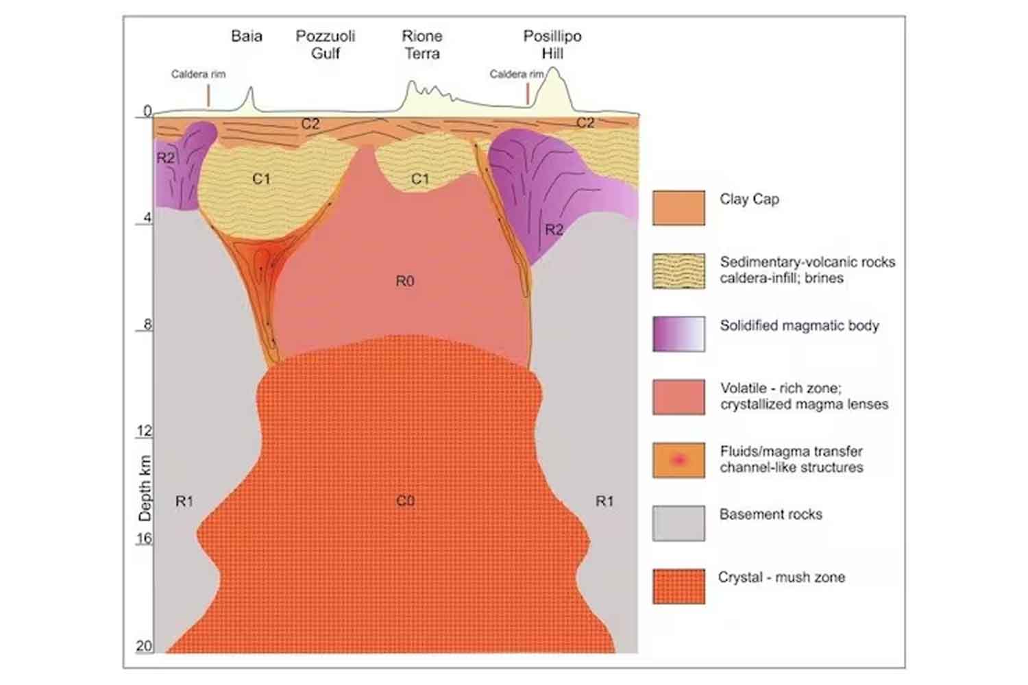
The study focused on the analysis of the electrical resistivity of the subsoil, parameter strongly influenced by the presence of fluids, such as saline water or partially melted magmatic materials. The approach adopted is that of Magnetotellurica (MT)a geophysical technique that detects the natural variations of the electric and magnetic terrestrial fields, providing a detailed map of the resistivity in depth.
Through thethree -dimensional reversal of electromagnetic datathe researchers have precisely reconstructed the areas where magma accumulates or dates back. In particular, the low resistivity areas were compatible with the presence of partially melted material. In addition, real real ones have been identified ski channelswhich could act as conduct for the transport of magma and gas through the earth’s crust.
Two transverse sections, called α and β, extracted long well -defined profiles of the caldera, show the distribution of the local seismicity in relation to the resistivity anomalies. The epicenter of the earthquakes, represented by white points, overlap with the areas of greatest geophysical interest, suggesting a direct connection between the seismic phenomena and the magmatic dynamics in progress.
Towards a more precise monitoring system and advanced predictive models
The results of this study arrive at a crucial moment, in which the area of Campi Flegrei is going through a new phase of Unrest volcaniccharacterized by increased seismicity and soil lifting. The new images obtained not only enrich the scientific knowledge of the volcanic system, but also offer fundamental tools to improve the real time monitoring and the development of predictive models more accurate.
The possibility of exploring up to 20 kilometers of depth marks an unprecedented technical and scientific milestone. The interdisciplinarity of the research and collaboration between international institutions underline the importance of an integrated approach to deal with the natural risks connected to complex volcanic systems such as that of the Flegrean camps.