
After over two centuries of hypotheses, eighteenth-century notes and references never verified in the field, theLost Roman aqueduct of the Villa dei Casoni has finally been identified and mapped with precision. The discovery, which occurred near Montopoli di Sabina, in Lazionot only solves an enigma opened in the 18th century, but brings to light a water system built before Rome definitively imposed its infrastructural model on the Sabine territory.
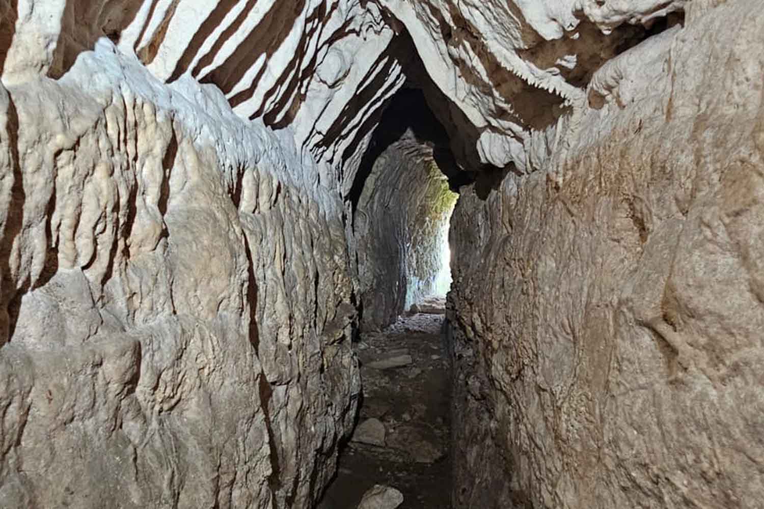
Under the terraces of the Villa dei Casoni, nestled on the hills of central Sabina, runs an underground canal that conveyed water from the springs to the residence. Following the walls carved in stone and the natural openings in the ground, Dr Nadia Fagianion behalf of the regional archaeological authority, demonstrated the exact point at which the conduit entered the villa’s water system.
These are not isolated segments, as long suggested by historical sources, but a coherent and integrated system. The tunnels dug into the living rock and the connected cistern testify to a continuous and organized flow. This confirmation finally allows us to associate the eighteenth-century descriptions with a real, traced and documented structure, offering a concrete basis for studying the entire network.
Already at the end of 18th century local scholars had reported traces of an ancient aqueduct and a spring later called Fonte Varrone. During the nineteenth century these references continued to be cited, but no one was ever able to reconstruct a precise path. Only thanks to accurate topographical surveys and field investigations was it possible to link those notes to actually existing tunnels, to collection points and to an underground entrance that had remained hidden for centuries.
About 300 meters from the villa there is a branched network that follows the natural slope of the land. Archaeologists define these passages as tunnels, narrow tunnels dug manually into the rock to channel water. The channels intercepted various sources, conveying them into a single collection chamber. A system as effective as it was delicate, which required constant maintenance: an obstruction or collapse was enough to interrupt the supply.
Before use, the water was poured into a tank equipped with limar poola settling tank designed to allow sand and sediment to settle to the bottom. Only after this process did the clearer water return to the conduits to supply the spa and fountains of the villa. Even so, however, seasonal floods could compromise the quality of the resource, making the protection of the springs essential.
The water shaped the entire architectural complex. The villa was organized on two descending terraces: at the bottom a landscaped garden with a circular swimming pool, at the top the private rooms. On the lower terrace a nymphaeum, a sort of garden sanctuary dedicated to water, constituted the scenographic fulcrum next to the pool. Without stable supplies, such a setup would have been impossible to maintain.
The 3D mapping that will protect the aqueduct
Some construction details suggest that the infrastructure may date back to an era preceding the full Romanization of Sabina. The system combines catchment and drainage in a manner typical of older rural engineering, rather than featuring a single monumental canal. It is plausible that a vicusa small agricultural settlement, carried out the first works, which were subsequently adapted to the villa.
The precise dating will depend on the analysis of the sediments and any finds found in the sealed layers, since the stone structures alone hardly provide certain chronological indications.
To definitively connect the underground tunnels to the structures visible on the surface, the team now plans comprehensive three-dimensional mapping. Through technology LiDARwhich uses laser pulses to measure distances in 3D without direct contactit will be possible to obtain a detailed representation of the entire hydraulic system and integrate it with the plan of the villa.
This procedure does not only have scientific purposes. It reduces the margin of error, limits invasive interventions and allows you to protect fragile tunnels, precisely identifying the areas in which any excavations can take place safely.
The contribution of the speleologists was also decisive, as they crossed very low corridors, documenting walls and directions that could not be reached by surface investigations. In collaboration with state heritage protection personnel, the Vespertilio d’Italia Speleo-Archaeological Group provided technical expertise and safety protocols to operate in complex environments. The memory of the residents also played a role: some owners remembered an old trough fed by the springs and directed the research towards the valley.
In addition to restoring historical dignity to the Villa dei Casoni, the Roman aqueduct tells how the hill communities of the Sabina managed water long before Rome imposed uniform standards in the countryside. From the ridge north-east of the capital, the site dominates the Tiber Valley and the Farfa river, a fundamental waterway for the local economy. By cross-referencing the new mapping with studies on soils and crops, researchers will be able to understand whether water control has contributed to keeping the territory productive for centuries.
The evidence collected among tunnels, springs and settling basins finally closes a question that was opened 250 years ago. Now it will be stratigraphic analyses, 3D mapping and rigorous access rules that will establish how much of this extraordinary aqueduct can be further studied or, one day, made visitable.