
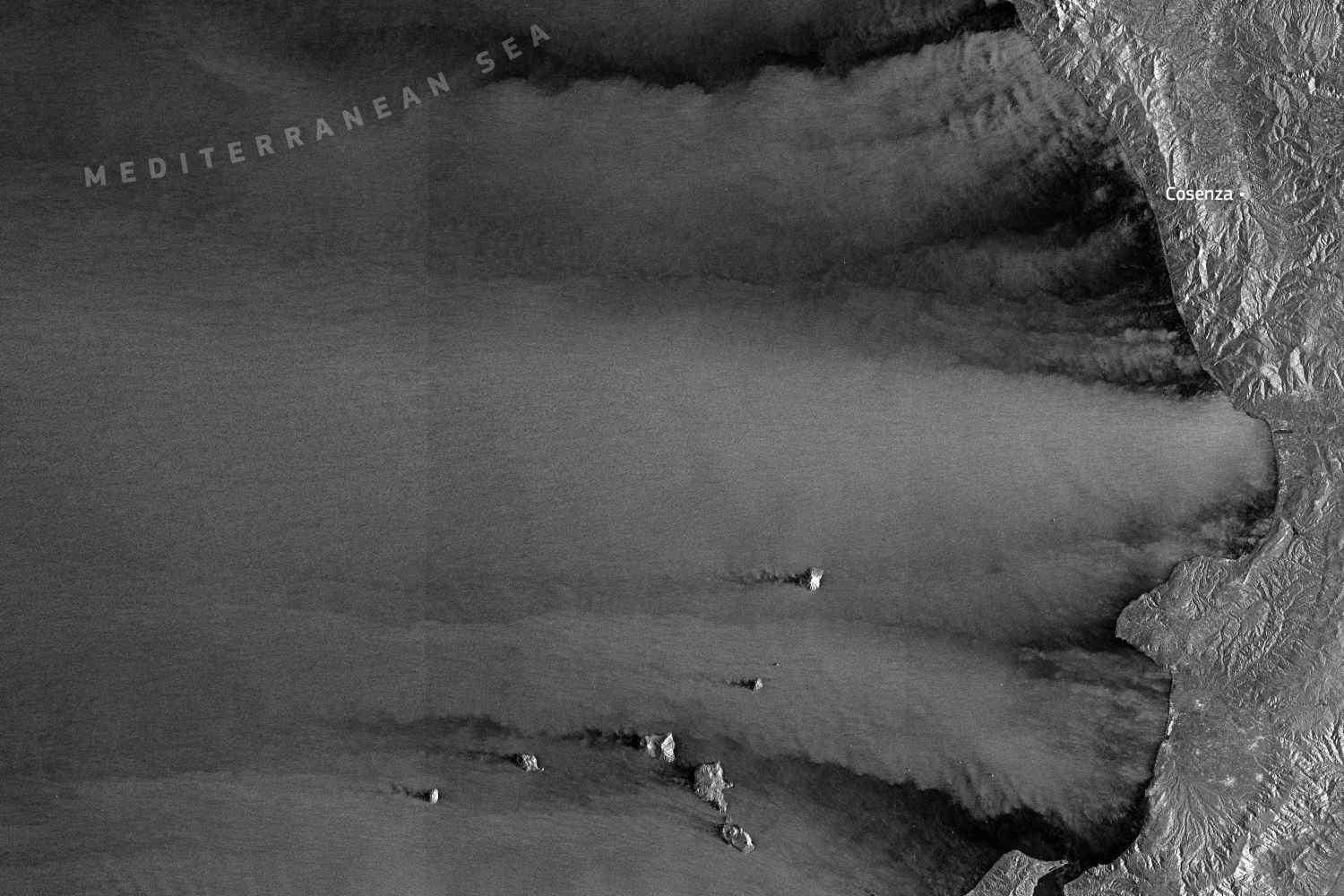
While the damage caused by Storm Harry is still being counted, a surprising interpretation comes from space. The cyclone, which hit Southern Italy in recent days with gusts over 120 km/h, was in fact observed by the Copernicus Sentinel-1 satellite, capable of telling what happens on the surface of the sea even when clouds and darkness prevent traditional vision. The image acquired on January 20, 2026 over the southern Tyrrhenian Sea is not only impressive, but scientifically valuable.
How Sentinel-1’s radar eye works
Sentinel-1 uses a synthetic aperture radar (SAR) that reads the roughness of the sea. Where the wind is strong, the sea surface ripples and reflects the radar signal, appearing clear. Where the sea is calmer, the signal becomes weak again and the image remains dark. This contrast allows us to precisely reconstruct the distribution of winds associated with the storm, even in extreme conditions.
The mountains as a natural shield
One of the most obvious aspects of the image is the presence of actual wind shadows along the coasts of Campania, Calabria and northern Sicily. Here the mountain ranges come into play, acting as a physical barrier, slowing down the currents and creating areas of relatively calm sea close to the coast. As soon as this natural protection disappears, the wind regains intensity and the sea appears rough again on the radar maps.
Islands and turbulence: the case of the Aeolian Islands
Another interesting detail concerns the area around the Aeolian Islands. The islands interrupt the flow of air, generating downwind contrails, turbulence and areas of apparent calm. These drawings, traced by radar on the surface of the sea, recall phenomena also observed in other island contexts, such as the Canary Islands or Madeira. It is the demonstration of how much the morphology of the territory influences the behavior of the atmosphere.
A key fact for the changing Mediterranean
Sentinel-1 images, which can be used day and night and in all weather conditions, are key tools for modeling winds and assessing storm impacts. In a Mediterranean increasingly exposed to intense events due to climate change, data like these help to understand where the sea will be more violent and where, instead, geography offers natural protection.
The first damage estimate is two billion euros
Cyclone Harry hit for three days with wind, intense rain and exceptional storm surges. In the meantime, the count of damage caused by Cyclone Harry on Sardinia, Sicily and Calabria has started. The first estimate speaks of around 2 billion euros. There are eroded beaches, destroyed coastal infrastructure, devastated ports and bathing establishments, with losses exceeding one billion in Sicily, half a billion in Sardinia and hundreds of millions in Calabria.
View this post on Instagram
View this post on Instagram
The Council of Ministers will meet next week to evaluate the declaration of the national state of emergency and appoint the regional presidents as commissioners, while the first allocations have already been made, such as the 70 million euros made available by Sicily. The authorities underline the priority of quickly restoring roads and services, also in view of the tourist season, while sectors such as fishing estimate losses of tens of millions and ask for urgent safety measures and economic support.
You might also be interested in: