
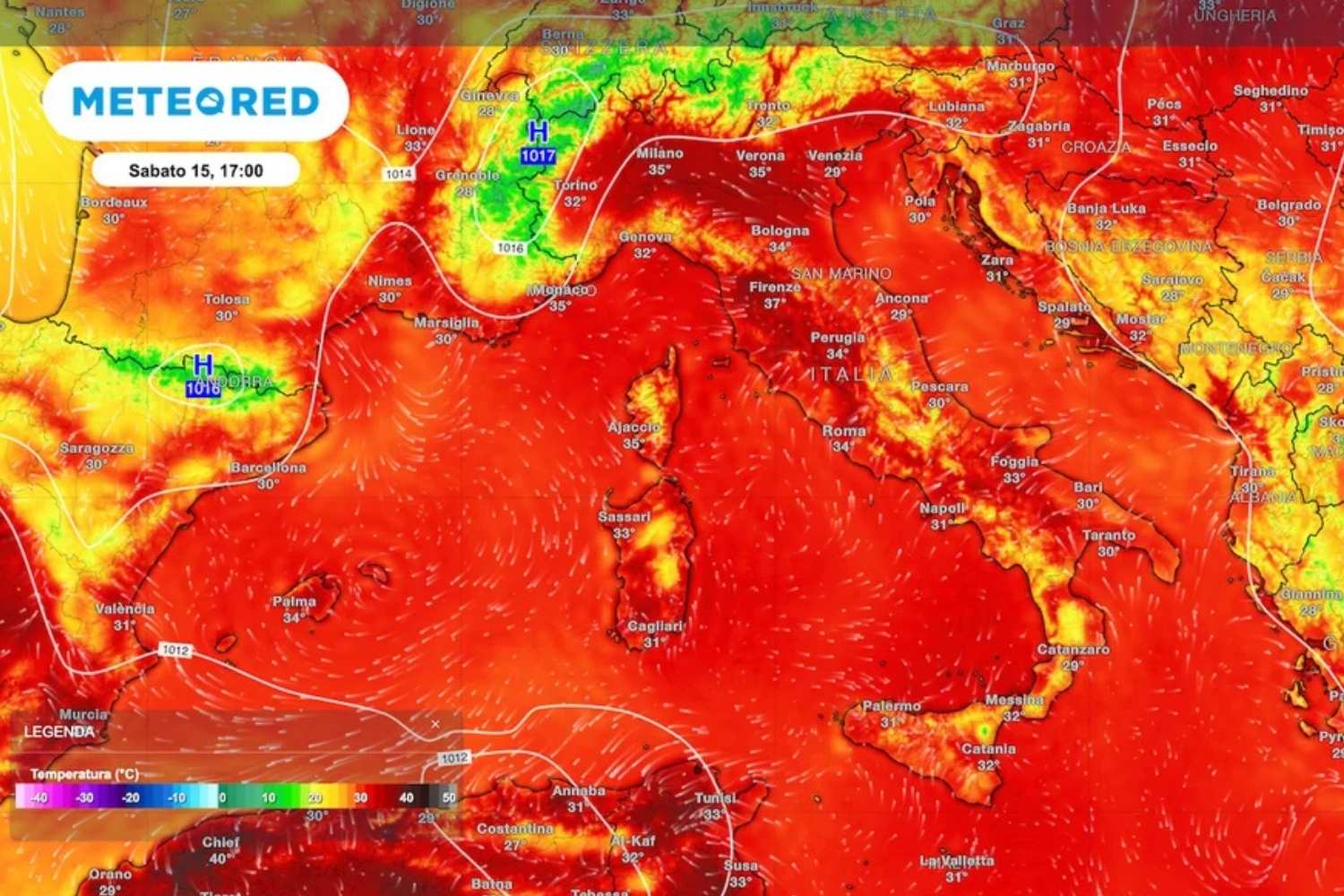
Fourteen days in a row with the mercury above 38 degrees: this is the data that comes from Florence and which, alone, measures the extent of this summer of 2026. It is not so much a problem of absolute records, but of duration: the Tuscan sequence even surpasses that of the torrid summer of 2003, which has always been taken as a yardstick for Italian heat waves. The storms that formed in the Alps and northern Apennines in recent days have in some cases touched the Po Valley, but without bringing relief to the cities.
The anticyclone resists, public health pays the bill
The synoptic picture described by meteorologist Luca Lombroso on Meteored Italia confirms that the subtropical anticyclone, partly of African origin, will remain firmly in command until the August 15th weekend. Only slight infiltrations of cooler and unstable air will reach the North, fueling the thermoconvective activity on the Alps and Apennines with local encroachments towards the plains.
This is no small detail, if you look at what is happening on the healthcare front. The Ministry of Health, which publishes daily bulletins on heat waves for 27 Italian cities from 25 May to 20 September, has recorded unprecedented alert peaks in recent weeks, with days in which all the monitored capitals were simultaneously in the red flag, level 3 which signals risk for the entire population and not just for the most vulnerable groups.
Thursday and Friday, the heat doesn’t let up
The next two days, Thursday 13th and Friday 14th August, remain dominated by scorching heat. The nights are tropical, with minimums that do not drop below 20°C, while in the afternoon the heat is felt with peaks of 36-37°C in the North and 38-39°C in the central cities. It is precisely the accumulation of heat that triggers afternoon thunderstorms in the Alps and Apennines between 2pm and 6pm: generally moderate, but capable of being violent on the Alpine mountains, where landslides and mudslides cannot be ruled out until the evening.
Hot mid-August, then the turning point is approaching
August 15 promises to be sunny on all Italian beaches, with heat that in the city can become oppressive and reach 38 degrees. Those who choose the mountains can count on a morning favorable for excursions, as long as they leave early: from early afternoon the cumulus clouds give way to heat thunderstorms, treacherous for those at high altitude.
On Sunday 16th the instability increases decisively, starting from the western Alps, with the first strong storms pushing towards Piedmont and involving the entire Apennine arc and the central-eastern Alps. Temperatures, however, show no signs of abating: they remain between 36 and 38°C across much of the peninsula.
From Monday the jet stream will bend, hail and downburst are coming
The real change begins on Monday 17 August, when the jet stream will begin to undulate, forming a trough that pushes a cold front over Italy. In the North, storms become organized and violent as early as the morning: the forecast advises against Alpine excursions and announces downpours, large hailstorms and downbursts in the Po Valley. The bad weather then spreads to the North-East, Tuscany, Umbria and Lazio, while Sardinia faces strong winds and the South records a temporary rise in temperatures linked to the prefrontal recall.
On Tuesday 18th the picture is divided into two: sunny spells in the North-West, but worsening in the North-East, Center and South, with intense thunderstorms in Emilia-Romagna and Triveneto and a real risk of destructive hail and gusts capable of damaging trees and structures in the central-southern regions.
A truce, not the end of summer
The passage of the front will bring a sharp drop in temperature, which however does not equate to a definitive farewell to the hot season: the brevity of the stormy phenomena will still leave temperatures high, between 32 and 35°C in the Centre-North and up to 38°C in the South, especially in Puglia. Furthermore, medium-long term projections indicate the possible return of the African anticyclone, ready to reassert itself strongly especially in the Centre-South. The sensation, if anything, is that of a pause: summer 2026 seems intent on being remembered for a while longer.
