
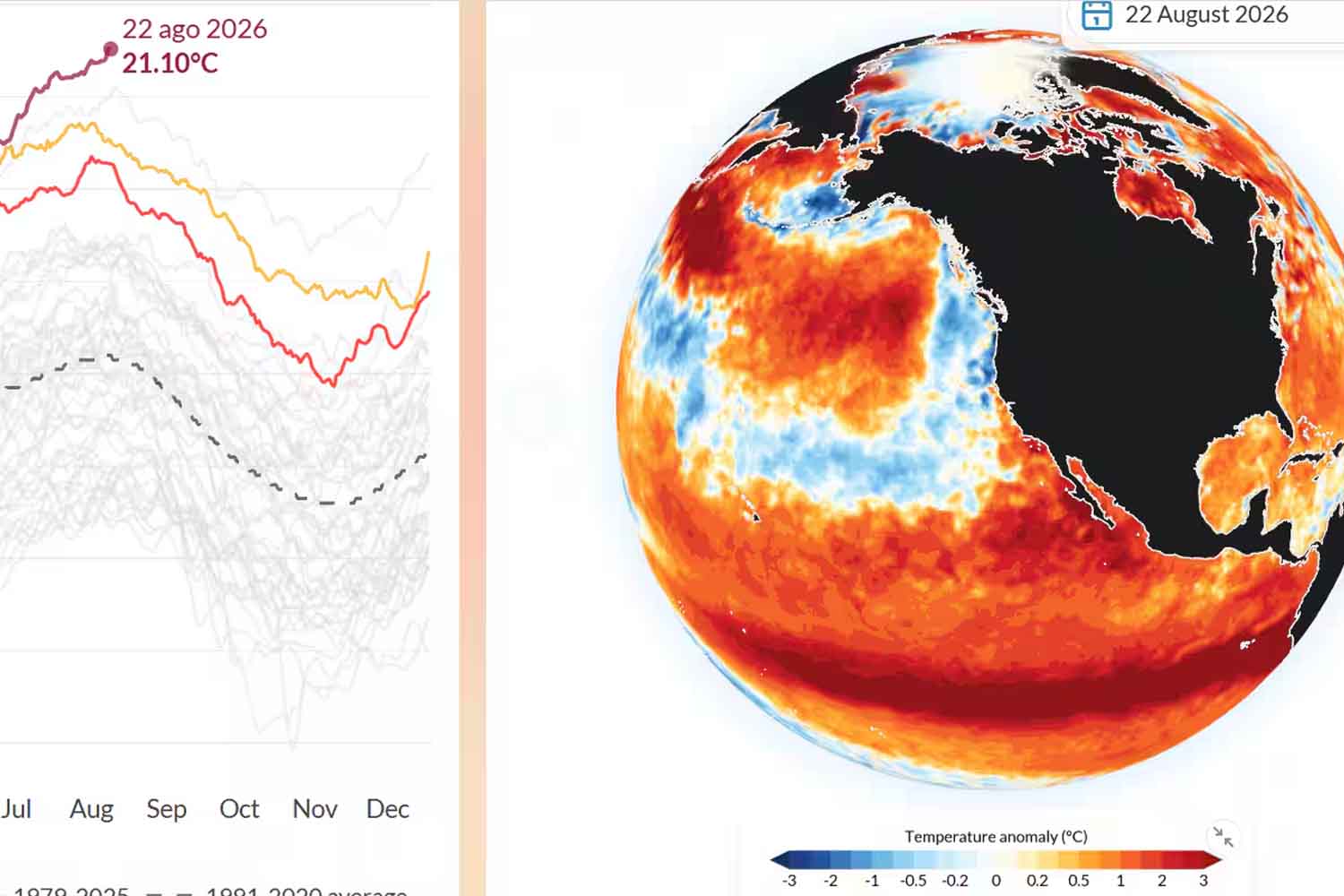
One hundredth of a degree, this time, was enough. On August 22, the average daily ocean surface temperature reached 21.1°C, exceeding the 21.09°C of March 2024. The new high was confirmed by the Copernicus Climate Change Service and comes as an El Niño is growing in the tropical Pacific that forecasts already describe as exceptionally intense.
The date makes the record even more conspicuous. Average ocean temperatures normally reach their maximum between March and April, after the southern summer. This time the curve rose to a record in the middle of August. The previous maximum observed this month was 20.98°C, recorded in 2023. We are now about 0.12°C above. An apparently tiny fraction, however spread over an expanse of water that embraces almost the entire planet.
The record comes after months of exceptionally warm oceans
The 21.1°C on August 22 did not appear as a solitary peak in the midst of a normal season. Throughout 2026, Copernicus observed a succession of records and near-record values for sea surface temperatures in the ocean between 60° south and 60° north. In June the monthly average reading had already reached 20.86 °C, the highest value ever recorded for that month in the ERA5 series used by the European service. Another monthly record arrived in July.
The graph published by Copernicus gives a good idea: the 2026 line runs above that of previous years precisely in the period in which it would normally begin to lose ground. From the sea, in short, the calendar seems to have frayed a bit.
©Copernicus
The data refers to the average sea surface temperature in the extrapolar global ocean, between 60°S and 60°N, reconstructed through the ECMWF ERA5 reanalysis. For this monitoring, data from 1979 onwards is used, when satellite observations become much more robust. The measure represents the so-called foundation temperaturesapproximately referable to water at a depth of about ten metres.
El Niño is accelerating in the Pacific
The tropical Pacific is being added to this already very warm ocean. NOAA’s Climate Prediction Center, in the August 13 update, describes a rapidly strengthening El Niño: in July the surface temperature anomaly in the Niño 3.4 region had reached +1.4 °C, while in the more eastern Niño 1+2 it reached +2.9 °C. Below the surface, in some areas, thermal anomalies even reached +10°C.
And we are still in the growth phase. According to NOAA, there is a greater than 90% probability that during the autumn and winter of 2026-2027 El Niño will reach very strong intensity. For the October-December quarter, the probability of entering the highest range predicted by the RONI index reaches 95%.
There is also a decidedly rarer scenario. NOAA estimates at 69% the probability that between October and December the RONI will reach at least +2.5 °C: a value which, according to the US agency, would exceed the intensity of the El Niño events present in its historical series since 1950. If the prediction is confirmed, the one that is growing in the Pacific will become among the most extreme episodes observed in recent decades.
The World Meteorological Organization also sees the same acceleration. Its model ensemble predicts a seasonal Pacific surface temperature anomaly of around 2.9°C for August-October, with a trajectory expected to continue rising until it peaks around November.
El Niño arrives over an ocean that was already warm
There’s some pretty heavy overlap going on. El Niño naturally transfers large amounts of heat from the Pacific to the atmosphere and changes atmospheric circulation on a planetary scale. This time, however, it is growing over oceans that come from decades of warming caused by human activities. It is this combination that makes 2026 particularly delicate.
Copernicus notes that over the past three years the global ocean outside the polar regions has remained between 0.35 and 0.73°C warmer than the long-term average. Already on June 21, 2026, sea surface temperatures had surpassed previous records for that day of the year. From there the race didn’t stop.
Samantha Burgess, Strategic Lead for Climate at ECMWF, describes the new high as a sign of an ocean under increasing stress. The most concrete data concerns marine heat waves: the number of days affected globally has more than tripled compared to the early 1990s.
When the sea accumulates too much heat
For corals, seagrasses and many other species, a few degrees higher for extended periods means living beyond the conditions to which they are adapted. Marine heat waves can damage habitats, displace species, alter food chains and even affect fisheries and aquaculture. In short, the sea thermometer also soon ends up on boats and in markets.
Then there is the water itself. As it warms up, it expands and takes up more volume: thermal expansion contributes to the rise of sea levels, adding its effect to the melting of glaciers and ice caps. For low-lying coasts and small islands it means greater exposure to flooding, erosion and saltwater ingress.
A warmer ocean also transfers more heat and moisture to the atmosphere, making more energy available when heavy rain and storm systems develop. And as it accumulates heat, it also becomes less efficient at absorbing carbon dioxide from the atmosphere, weakening one of the great natural sinks that have so far held back some of our emissions.
Copernicus will now continue to follow the curve to understand how long the new high will last. Meanwhile, El Niño has yet to reach the peak predicted for the final months of the year. The oceans, however, reached 21.1°C already on August 22nd. And this time the record arrived a few months ahead of schedule and a few months ahead of schedule in the Pacific.
