
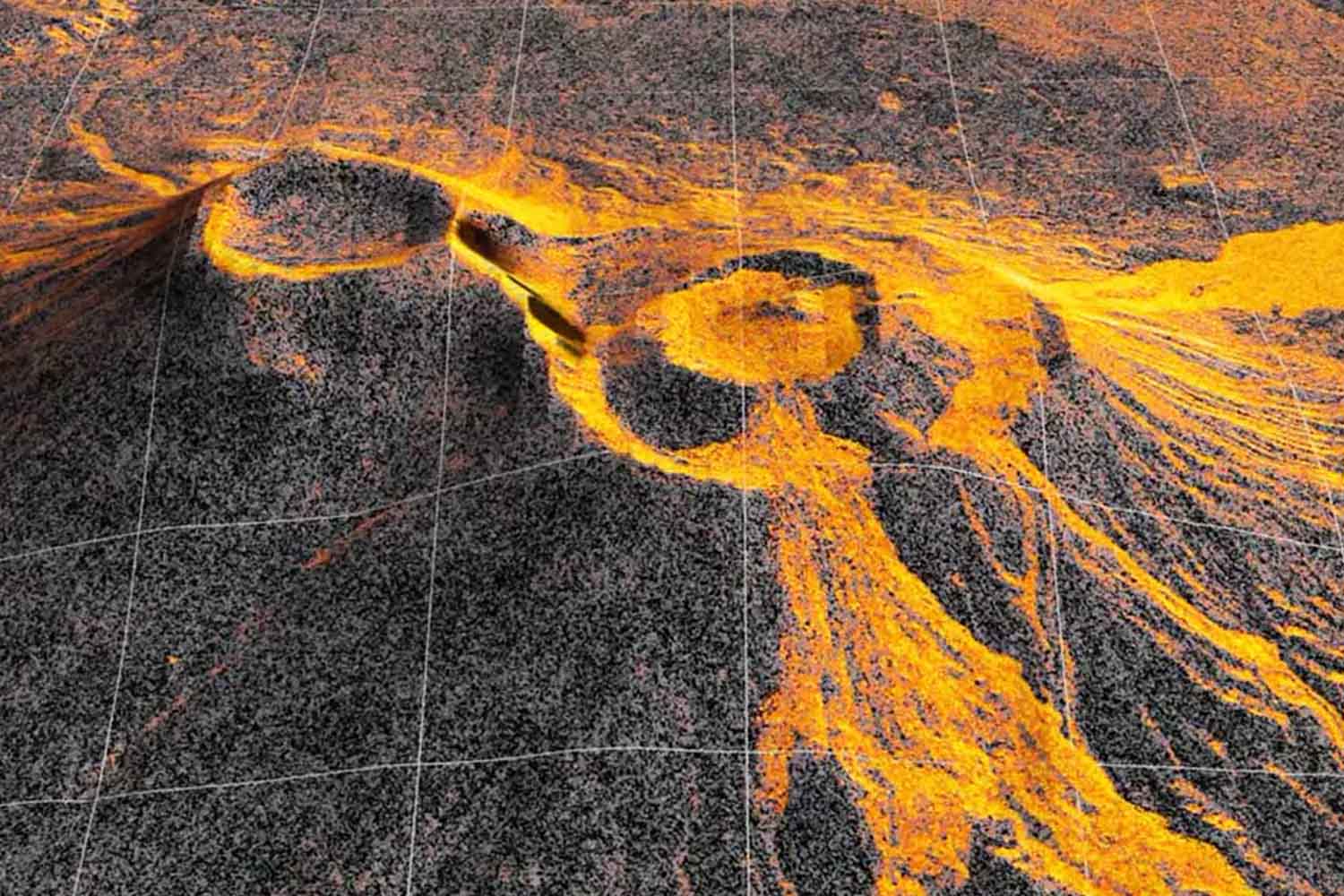
On December 25, 2025, the NISAR satellite aimed its radar at Krasheninnikov, on the Russian Kamchatka peninsula. Over the next few months he returned to the same spot often enough to turn the eruption into a pattern: 17 images show the lava filling an internal depression, exceeding its edges and spreading eastward like a fan. The volcano had returned to activity a few months earlier, after a silence that lasted almost five centuries. NASA released the time-lapse on September 24, 2026.
The detail that complicates the story comes three days before the eruption. The July 30, 2025 an earthquake of magnitude 8.8 it had hit the ocean off Kamchatka. On August 2, Krasheninnikov began to erupt. The temporal proximity is evident; the cause and effect relationship, much less. NASA writes that the earthquake apparently “awakened” one of the two volcanoes, but establishing how much it contributed to the eruption requires much more caution.
A volcano that had not erupted since the sixteenth century
Krasheninnikov is located in the eastern Kamchatka volcanic arc, one of the most volcanically active regions on the planet. According to the Smithsonian Institution’s Global Volcanism Program, the last previous confirmed eruption was approximately 1550. The one that began in August 2025 is therefore the first known for about 475 years.
At 4.50 pm on August 2, 2025, local time, explosions with columns of ash initially high between 3 and 4 kilometers above sea level. On the northwestern flank, a fracture also opened from which viscous lava began to emerge. In the following hours, some ash columns reached 8-10 kilometers in altitude, according to the Smithsonian and USGS report on the beginning of the eruption.
When NISAR began observing the area regularly, at Christmas, the activity had already been going on for almost five months. The satellite has since returned twice every twelve daysone during the passage from south to north and one in the opposite direction. The 17 acquisitions used for the video go up to mid-August 2026.
Lava can also be seen under clouds
The images look quite different from spectacular photographs of an eruption taken from space. NISAR, a joint mission of NASA and the Indian space agency ISRO, uses a synthetic aperture radarwhich sends thousands of microwave pulses toward the surface every second and measures the signal that comes back.
In the time-lapse, the lava appears lighter than the surrounding terrain because it reflects the radar signal differently than snow or exposed rock. Each pixel corresponds to a surface area of approximately 10 meters by 10 metersmore or less half of a tennis court. And the clouds, quite frequent over Kamchatka, cease to be a major obstacle: the radar can collect data even through cloud cover.
The sequence thus follows the material as it fills an internal area of the crater, overflows into the larger one and continues to widen towards the east. A second flow directed to the northwest also appears, probably formed before the first image acquired by NISAR.
A satellite that passes over almost all active volcanoes
NISAR was launched on July 30, 2025 and orbits at approx 747 kilometers from Earth. It carries two radar systems, one L-band made by NASA and one S-band provided by ISRO. It is the first free satellite mission in space to bring radars working on these two wavelengths together.
The L-band radar, the one used for the Krasheninnikov images, uses longer waves capable of also crossing the treetops and observing the ground below. The NISAR mission was designed to track changes in the Earth’s surface, ice, vegetation and natural phenomena such as earthquakes, landslides and volcanic eruptions.
According to NASA, its coverage allows you to observe practically all the surroundings 1,300 active volcanoes above sea level. For Matthew Pritchard, a geophysicist at Cornell University and member of the NISAR scientific team that analyzed this data, the advantage lies above all in the regularity: same place, close intervals and two directions of observation.
For a remote volcano that has remained quiet long enough to not have an instrument network as dense as its more restless neighbors, that means suddenly having a pair of eyes 747 kilometers up in the air.
Time-lapse tells above all where the lava arrived and how the surface changed over the months. However, it does not resolve the most difficult question about the beginning of the eruption: how much that 8.8 magnitude earthquake that occurred just three days earlier really mattered. After almost five centuries of silence, Krasheninnikov is moving again. This time, however, a radar passed above him regularly.
