
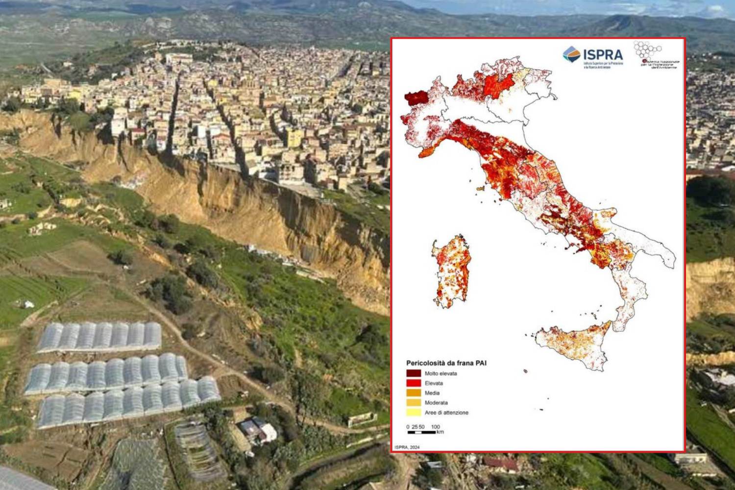
The damage caused by Cyclone Harry, which devastated the Sicilian coast with waves up to 10 meters high and winds of 120 km/h, and the enormous landslide into which Niscemi is sinking are only the latest chapter in a story whose protagonist is an increasingly fragile Southern Italy, which has now become the breaking point of climate change.
But almost everywhere, extreme phenomena are taking place with a frequency never seen before, putting the resilience of local communities and infrastructure to the test. The images arriving from the devastated territories are a tragic confirmation of a structural vulnerability that the country can no longer ignore.
According to data from the Center for Studies on Climate Change, in Sicily over 70% of the territory is at risk of desertification, and extreme events, such as heat waves, prolonged droughts, flash floods and coastal erosion, are now a constant.
View this post on Instagram
Hydrogeological instability in Italy, ISPRA data
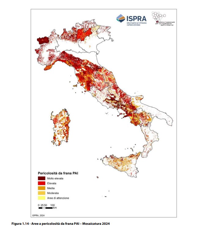
Hydrogeological instability undoubtedly represents a growing threat to Italy, as highlighted by the Fourth ISPRA Report on Hydrogeological Disaster in Italy – 2024 Editionwhich puts the phenomena that affected the country between 2022 and 2024 under a magnifying glass, providing a detailed picture of landslides, floods, avalanches, coastal erosion and associated risks throughout the national territory.
The most alarming data emerge in relation to the danger from landslides: in the period 2021-2024, the surface area at risk increased by 15%, going from 55,400 square km to 69,500 square km, equal to 23% of the national territory.
The most affected regions are:
and the Autonomous Province of Bolzano (+61.2%)
This increase is mainly due to the carrying out of more detailed studies by the basin authorities and the autonomous provinces. The high risk areas (P3 and P4) went from 8.7% to 9.5% of the territory.
The three-year period 2022-2024 was marked by extreme hydro-meteorological events, including floods in the Marche in September 2022, mudslides in Ischia in November 2022 (with 12 victims), devastating floods in Emilia-Romagna in May 2023 and intense rainfall in Valle d’Aosta and Piedmont in June 2024. These events were accentuated by changes climate, which led to an increase in intense and concentrated rainfall, amplifying the risk of surface landslides, mudslides and floods.
Landslides: 5.7 million people at risk
According to the ISPRA Inventory of Landslide Phenomena in Italy (IFFI), there are over 636,000 landslides registered in the country, with 28% characterized by rapid and highly destructive dynamics.
This direct impact concerns approximately 5.7 million Italians, of which 1.28 million reside in very high risk areas (P3 and P4), corresponding to 2.2% of the population. Over 582,000 families, 742,000 buildings, approximately 75,000 local business units and 14,000 cultural assets are exposed to these risks.
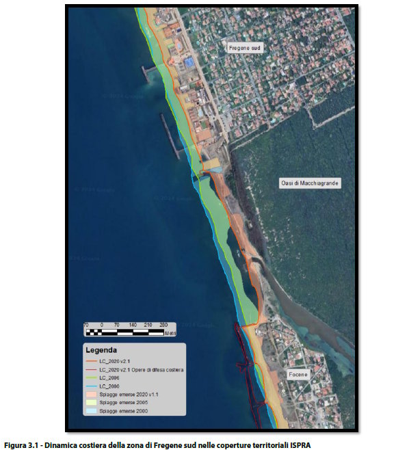
Coastal erosion
On the coastal erosion side, the situation has shown signs of improvement: between 2006 and 2020, 1,890 km of beaches subject to significant changes were recorded, with a clear prevalence of advancing stretches (+30 km) compared to eroding ones. This result is attributable to the nourishment and coastal protection interventions, which are reversing the trend.
The avalanches
As for avalanches, the surface potentially subject to these phenomena is equal to 9,283 km², or 13.8% of the mountain territory above 800 meters above sea level. For the first time, ISPRA has created a harmonized national cartography, thanks to the collaboration with AINEVA, the Meteomont Service of the Carabinieri and the competent Regions.
In short, the ISPRA data confirm that the risk of hydrogeological instability is a growing reality, with serious implications for the safety of millions of Italians and for the protection of the country’s natural and cultural heritage. The challenge is to face these risks with greater awareness and adequate resources, to protect our territory and our population.