
We are experiencing a “super El Niño”: according to the MetOfficethe UK’s national weather and climate service and world-class institution, 2026 will go down in history for the development of the largest El Niño in living memory, likely the largest such event since the 19th century. And the forecasts do not improve at all in the future, on the contrary.
El Niño 2026
We must point out that this is an unprecedented event – explains Adam Scaife, head of long-term forecasts at the Met Office – I have never seen such an intense El Niño signal in our forecasts. A typical El Niño leads to an equatorial Pacific surface temperature increase of between 1 and 2 degrees, with 2°C being a truly significant event. This implies that, if the forecast is accurate – and other forecasting systems show similar extremes – then 2026 will far surpass our recent experience of El Niño and its effects on global climate
The expected increase is in fact greater than 3°C, something exceptional and potentially very dangerous: the analysis of historical data and computer simulations also highlight the global rainfall anomalies caused by El Niño, well documented in several impact and humanitarian studies which describe in detail the more sector-specific effects.
©Met Office
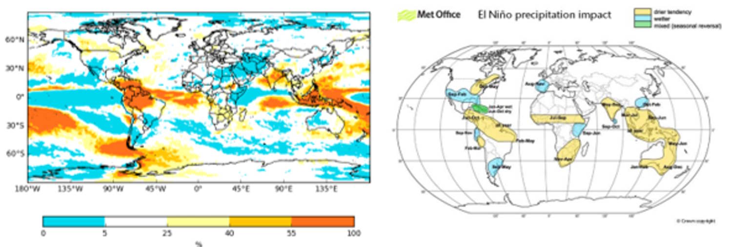
Just to cite one example, the Indian summer monsoon is one of the regional weather patterns affected by the intensifying El Niño, and its rainfall is already well below normal. Other regions at risk of low precipitation include Central America, the Western Pacific nations, and tropical South America.
©Met Office
And it doesn’t end here: El Niño also influences tropical cyclones and suppresses Atlantic hurricanes, increasing the wind shearthat is, the sudden change in wind speed or direction, or both, over a short distance in the atmosphere, which can occur horizontally relative to the ground or vertically with rising altitude.
In line with this, there have only been three storms so far this season, but it only takes one large hurricane to cause devastating impacts.
What will happen in the future?
El Niño is intensifying, reaching its peak in winter, and its impacts will affect not only the tropics, but also the mid-latitudes: the Met Officetherefore, predicts that southern Africa and northeastern Australia will be at greatest risk of drought.
Its influence will also start to increase the chances of wetter and stormier conditions for northwestern Europe next autumn and early winter.
Precipitation forecasts indicate drought: the probability of seasonal precipitation is in fact very low, calculated on average between September and November: the red areas are at greater risk and, in many cases, coincide with the historical impacts of El Niño.
The events of El Niño they also cause an increase in average global temperature.
During large El Niño events, significantly more heat is released from the ocean into the atmosphere, leading to an increase in global average temperatures, particularly in the calendar year following El Niño’s winter peak. Therefore, it is highly likely that 2027 will surpass 2024 as the warmest year on record and will be another year of temporarily surpassing +1.5°C above the pre-industrial period.
Warning: speaking of El Niño refers to completely natural climate changes, which however, in a context of anthropogenic global warming, are even more worrying.
This summer we have seen heat waves across Europe, reminding us of the effects of climate change – reports Stephen Belcher, head of science and technology at the Met Office – This intense El Niño reminds us that natural variations in the climate system are also at play, exacerbating the pressures of climate change
This is why it is even more urgent to intervene on emissions and in general on the management of human activities.
