
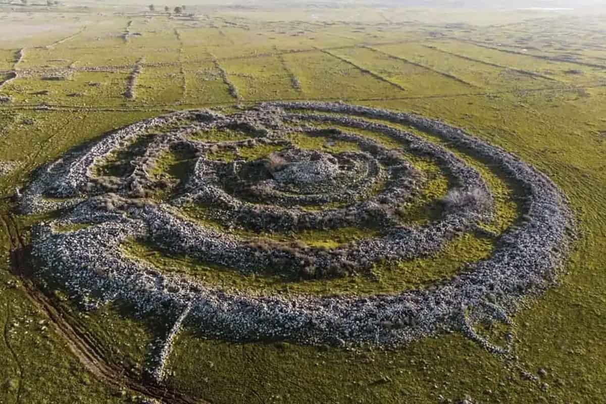
A stone circle 250 meters wide, built around a small volcanic cone. Four walls that start from the edge and reach the center, like the spokes of a giant wheel. Archaeologists called it Circle 9 and identified it in the Golan Heights, a few kilometers from one of the most enigmatic prehistoric monuments in the Middle East. And they found 27 other similar circles in the same area.
The discovery concerns Rujm el-Hiri, nicknamed “Stonehenge of the East”a huge complex of stones dating back thousands of years, whose function continues to elude archaeologists. For decades it was considered an almost unique construction of its kind. Now satellite images have shown that there is a whole series of circular structures around that monument, some even larger.
They are documented by a study published in PLOS Oneconducted by a team of researchers led by Ben-Gurion University of the Negev. And while archaeologists try to figure out what all those circles were for, other research has added a complication: Rujm el-Hiri may have moved and changed orientation over the millenniaalong with the land on which it was built. A detail that puts into difficulty one of the most fascinating hypotheses on its origin: that of an ancient astronomical observatory.
A giant stone wheel built thousands of years ago
To understand the discovery we must start from the original monument, which is located on the Golan Heights, a Syrian territory occupied by Israel, north-east of Lake Tiberias. Rujm el-Hiri was discovered in 1968 by archaeologist Yizhaki Gal, while examining military aerial photographs. A rather curious discovery, because the monument had always been there, clearly visible on the ground. It was his overall form that eluded observers.
From the ground, in fact, it appears as a succession of dark stone walls, partly collapsed and covered by vegetation. Looking at it from above, however, you can recognize an imposing structure: four large concentric rings, connected by walls that head towards the centerwhere there is a mound of stones about five meters high.
The overall diameter exceeds 150 meters. Some walls still reach two and a half meters in height and over three meters in width. All made with basalt stones, a very common volcanic rock in the region. The construction dates back to recent prehistory, probably between the Chalcolithic period, when humans began working copper, and the Bronze Age. The exact dating of the different parts of the monument is still debated.
And then there is its function, which archaeologists have been wondering about for over half a century. According to some interpretations, Rujm el-Hiri may have been used for collective ceremonies. Other scholars have proposed a funerary function, perhaps linked to the burial of an important person, or a meeting place for the communities that inhabited the region.
There are also those who imagined something more complex: an astronomical observatory, capable of marking the passage of the seasons through the position of the Sun. A hypothesis born from the orientation of some entrances and walls, which seemed to correspond to particular celestial phenomena, such as the rising of the Sun during the summer solstice. For a people who lived on agriculture and livestock, knowing the cycle of the seasons was certainly important. But establishing whether those stones were placed precisely to observe the sky is another matter entirely.
The satellites have identified 28 circles: one measures 250 meters
The new research has changed the scale of the problem, literally. By examining high-resolution satellite images, taken in different years and seasons, the researchers identified 28 large circular structures within 25 kilometers of Rujm el-Hiri. Only two had already been recorded in previous archaeological surveys.
The others had escaped scholars, often because they were partially collapsed, covered by vegetation or confused with the numerous stone walls present in the area. The images taken in different seasons allowed us to better distinguish the structures. An almost invisible wall under a certain type of lighting can become recognizable when the Sun changes position or the vegetation thins out.
Many circles have two or three concentric rings, built with basalt stones. Some measure approximately 50 meters in diameter, others exceed 100. In several cases there are internal walls that divide the space into sectors. Then there is Circle 9, the largest among those surveyed. It measures approximately 250 meters in diameter and is located about 300 meters from a small tributary of the Gilbon stream. Its outer wall reaches a width of five meters and surrounds a volcanic cone connected to the perimeter by four thinner walls.
In other parts of the territory the structures appear to form small groups. Two circles, for example, are about 25 meters away from each other. Others feature long walls that may have connected different buildings. Archaeologists also observed a common feature: many monuments stand near seasonal watercourses and ancient field delimitation systems.
Dolmens, prehistoric tombs made with large stone slabs, and tumuli, i.e. accumulations of stones or earth that could have had a funerary function, often appear nearby. A distribution that can hardly be ignored, even if it remains to be verified which structures were built in the same period and which were added later.
Those circles could tell the story of the lives of entire communities
The presence of so many similar monuments suggests that Rujm el-Hiri was part of a widespread building tradition in the region. As archaeologist Michal Birkenfeld explained in the official presentation of the research published by Ben-Gurion University, the monument appears today as the most impressive example of a much broader phenomenon, probably linked to the social and economic life of ancient populations.
The circles may have been places intended for meetings, ceremonies or points of reference for communities of farmers and breeders. Let’s think of groups of people who moved with their animals following the availability of water and pastures. Having recognizable places in the landscape could be useful for meeting, organizing collective activities or marking particular areas of the territory.
These are possibilities that researchers are taking into consideration, also because many circles seem to be inserted into a larger network of walls, fences and other constructions. However, one crucial element is missing: most of the structures have not yet been excavated. Satellite images allow us to recognize the walls and study their layout, but alone they cannot tell what was happening inside them.
The “Stonehenge of the East” would have moved tens of meters
As if 28 mysterious circles weren’t enough, previous research also called into question the monument’s original orientation. In November 2024, a study published in the journal Remote Sensing examined the geological movements of the region through satellite data, GPS measurements and analysis of the magnetic properties of rocks.
The authors reconstructed a slow anti-clockwise rotation of the area where Rujm el-Hiri stands. The Earth’s surface, in fact, moves continuously due to tectonic forces, i.e. the movements that affect large portions of the crust of our planet. Generally we are talking about movements of a few millimeters per year, impossible to perceive without adequate instruments.
Over thousands of years, however, even such small movements can accumulate. According to the model used by the researchers, Rujm el-Hiri may have moved about 30 meters over 4,000 yearsaccompanying the movement of the ground. This is an estimate obtained from regional geological reconstruction, not a displacement measured directly on the monument. For the astronomical hypothesis, the most important detail is above all the possible rotation.
If an entrance was built to look exactly towards a certain point on the horizon, its original orientation would have changed along with the terrain. Looking at the direction of that passage today could therefore lead us to the wrong conclusions about what the builders wanted to see thousands of years ago.
Previous studies had looked for correspondences between the entrances, the walls and the position of the stars in antiquity, but considered the structure essentially still in its original position. The new geological reconstruction suggests that this hypothesis needs to be re-examined. This does not mean that Rujm el-Hiri had no astronomical significance. However, the authors believe that current alignments alone are not sufficient to demonstrate this.
The mystery of the stone circles has become much bigger
The two studies, published just over a year apart, tell a different story than the one archaeologists had imagined for decades. Rujm el-Hiri may have been part of a network of monuments linked to the lives of the communities that inhabited the Golan thousands of years ago. Its architecture, considered exceptional, bears similarities to many other structures scattered across the region.
There remain several things to clarify. First of all, the age of the new rims. Their shapes may resemble each other even if they were built in different periods. Some show traces of later modifications, with walls added over older structures. Excavations, analysis of the materials and new archaeological investigations will therefore be needed to establish who built them and what their use was.
For almost sixty years, Rujm el-Hiri has been studied as an almost isolated monument, with its gigantic stone rings and as yet unknown function. We now know that at least 28 other large circles exist nearby. Satellites showed where to look. For most of those structures, archaeologists have yet to begin excavating.
