
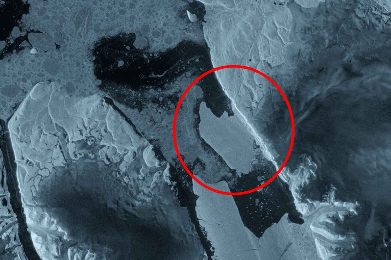
The crack was already clearly visible on August 3, 2026. Twenty-four hours later, a 76.4 square kilometer ice island had broken off from the eastern side of the Petermann Glacier in northwestern Greenland. To have a less abstract measurement, it is larger than the entire municipal territory of Cremona, which is just over 70 km². And above all it is up to 150 meters thick. The Sentinel-1 radar followed the birth of the new iceberg practically live, even through clouds and Arctic darkness.
It is the largest calving of floating ice from the Petermann since 2012 and, according to the European Space Agency, the most important calving observed in the Arctic since 2020. The term simply indicates the detachment of a mass of ice from the front of a glacier. The name is simple, the mass that now floats in the Arctic is a little less so. The ESA defines it as a real “ice island”, a tabular ice island with an almost flat surface.
©ESA
The Petermann had been breaking down before the eyes of the satellites for months
The posting on August 4 did not come out of nowhere. Since 2019, an international group made up of researchers from the University of Ottawa, the British universities of Stirling, Lancaster and Leeds and the Canadian Ice Service has been following the evolution of the Petermann’s floating tongue. The fractures had been growing for years. By April 2026, interferometric observations from Sentinel-1 already showed deformations and cracks running through the ice; by August 3, deterioration along the central portion had become evident. By 20 UTC the next day, the eastern piece had separated.
The Petermann already has some experience in producing notable ice islands. Large gaps occurred in 2008, 2010 and 2012; precisely those of 2010 and 2012 heavily shortened its floating tongue. Since then the front had remained relatively more stable, except for minor episodes. This time the satellites were also able to observe the propagation of fractures with an exceptionally high frequency, thanks to the close-up radar acquisitions of Sentinel-1C and Sentinel-1D.
And the piece that has just started could only be the first. The most recent estimates published by ESA indicate two more portions of around 97 and 87 square kilometers could separate as existing fractures continue to advance. Initial estimates from the University of Ottawa, released on August 7, were slightly lower, 94 and 84 km². The measurements are therefore still estimates on a system that is changing under the instruments.
Why such a large iceberg becomes a problem for ships
The 76.4 km² block does not become dangerous because it suddenly decides to behave like the Titanic iceberg. The problem comes above all with time. Masses of this size can remain adrift for years and progressively break into smaller fragments, which are much less easy to identify and follow.
This is why Environment and Climate Change Canada is monitoring the island’s trajectory and assessing possible risks to shipping and offshore infrastructure. Abigail Dalton, of the Canadian Ice Service, explains that fragmentation transforms large, easily recognizable blocks into pieces that are more difficult to trace. The Canadian Ice Service maintains maps, alerts and forecasts dedicated to Canadian navigable waters, where ice and icebergs are already part of normal Arctic maritime traffic management.
Baffin Bay and the Nares Strait are also natural corridors for the transport of ice towards the south. Official Canadian climatologies describe the inflow of old ice from the Arctic Ocean through Nares Strait and a current-driven circulation of icebergs in Baffin Bay. This makes it important to know where the new giant will go, without however transforming the detachment into a general alarm for global navigation: the risk being assessed concerns the routes and Arctic activities along its possible trajectory.
Detachment and climate change are not the same thing
Then there is a necessary distinction. A glacier reaching the sea naturally produces icebergs and it is not possible to automatically attribute this single calving to climate change. The calving it is part of the dynamics of marine glaciers and also depends on geometry, fractures, tides and ocean conditions.
The Petermann, however, moves within a warming Arctic and its floating tongue is particularly sensitive to what is happening below the surface. NASA has documented how warmer ocean waters help melt ice from below, especially near the waterline, where the glacier stops resting on the seabed. Some measurements have recorded melting rates of up to 80 meters per year in that area.
Here too it is important to distinguish two things. The chunk that broke off was already floating, so its melting doesn’t directly produce the same sea-level rise as ice moving from land to ocean. The floating tongues, however, can exert a sort of brake on the ice behind them. A study published in Nature Communications showed through modeling that a much larger break-up of the Petermann shelf could reduce this support and increase the discharge of continental ice to the sea. The new detachment, alone, does not allow us to say that this is already happening.
This is also why the 76 square kilometer block is of such interest to researchers. Large ice islands are much more common around Antarctica and relatively rare in the Arctic. Now satellites, aerial observations and tracking systems will follow this piece as it drifts, wears out and possibly begins to break down.
Meanwhile, on the Petermann the cracks that remained in place continue to advance. The large iceberg is already in the sea. The next two, for now, are still attached. And it is precisely that difference that Sentinel-1 will continue to measure.
