
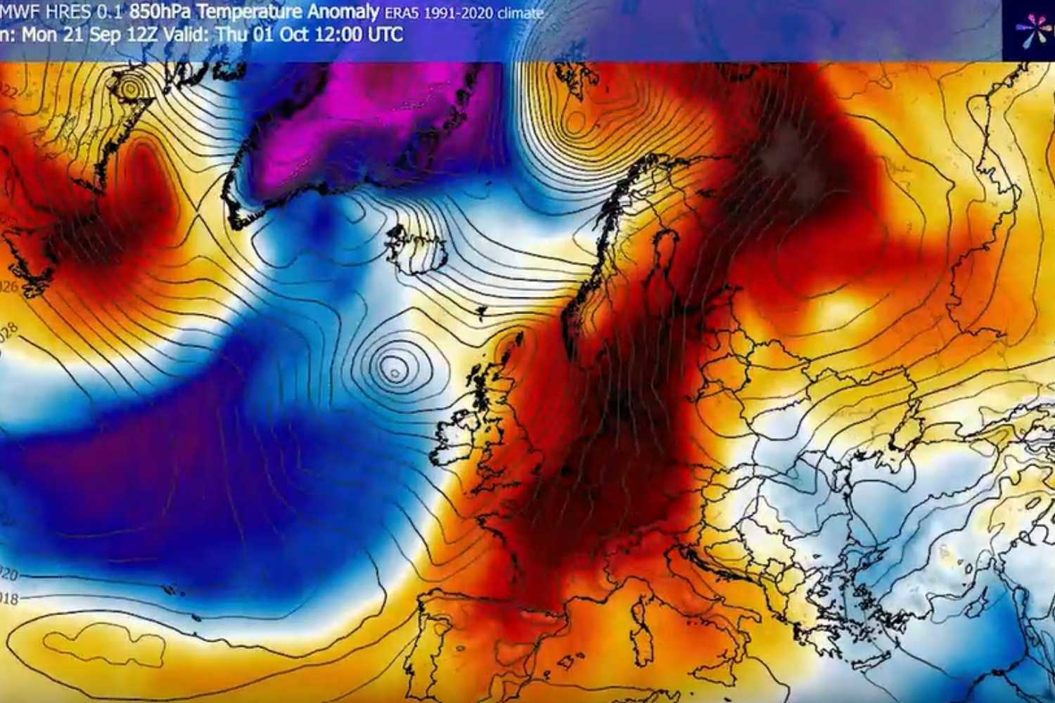
Autumn is now upon us: the equinox will start on September 23rd, precisely at night. But the change of season, at least from a meteorological point of view, will not immediately coincide with the arrival of the cold. In fact, the main models predict a rather unusual scenario for the end of September and the beginning of October, with a vast heat dome ready to expand from the Mediterranean and North Africa towards much of Europe. Temperatures could reach 24-25°C in south-east England, while some parts of Italy will hit highs of 30°C.
@Wxcharts.com
A powerful high pressure structure, fed by a deep depression in the North Atlantic, will favor the rise of warm air masses of subtropical origin towards the heart of the continent. In several European areas, temperatures at an altitude of around 1,500 meters (850 hPa) could exceed seasonal averages by as much as 8-12 °C, giving days with a summery feel well beyond the usual period. But what will the weather situation be like on our peninsula?
Italy split in two (between heat and first signs of autumn)
However, the transition to autumn will not be uniform across the entire national territory. Already from the early hours of Tuesday 22 September, the North-East will begin to perceive a decisive change of scenery thanks to the arrival of cooler air from Scandinavia, connected to a deep low pressure area.
The refreshment will mainly affect the Adriatic regions, where the northern winds could cause a significant drop in temperatures, in some cases even by 10°C compared to the previous days. The Adriatic will in fact be one of the sectors most affected by the change in air mass. The situation is different on the western side of the Peninsula: here the heat will last longer, with a less marked decrease especially in Sardinia, still influenced by the milder currents.
However, with the arrival of the equinox, a general drop in temperatures is expected in Italy, even if the picture will remain very variable.
The heat dome affecting Europe
The exceptionally hot temperatures that will affect the Old Continent are linked to the presence of a robust anticyclone which acts as a real atmospheric “lid”. The hot air is pushed downwards through a process called subsidence: during its descent it compresses, further increasing its temperature and hindering the formation of clouds. The result is very sunny days, with dry air and temperature values significantly above average.
According to the experts at SevereWeather.eu, the anomalous heat will mainly affect western and southern Europe. Between Spain and Portugal the air column will remain particularly dry and could favor temperatures between 34 and 38 °C, with local peaks close to 40 °C by the weekend.
The heat will also reach France, with values of up to 36°C in the southern areas and temperatures around 30-32°C in the northern areas and the Benelux. Italy and the Balkans will also be involved in the warm recovery, with peaks of up to 28-30 °C in the Po Valley and Tuscany.
The situation will be particularly unique because, while Italy will gradually begin to lose part of the accumulated heat, Western Europe will continue to experience almost summer-like conditions. On the Iberian Peninsula, in fact, the hot anticyclone will remain the protagonist even in the days following the equinox, maintaining high temperatures for the period. The expansion of the anticyclonic structure towards the North will also bring important thermal anomalies to Scandinavia, especially between Sweden and Finland, where the beginning of October could be unusually mild.
Heavy rain on the Atlantic side
However, the European scenario will be characterized by a strong contrast. While much of the continent will remain protected by the warm and stable air of the anticyclone, on the western side an intense flow of humid currents coming from the Atlantic will be activated. In fact, a sort of humidity corridor will form between the high pressure and the Atlantic depression directed towards the British Isles and Norway. In these areas, heavy rainfall could occur, with accumulations that could locally exceed 150 millimeters in a few days.
Weather models indicate that this configuration could persist for several days, although its precise duration will be confirmed with future updates.
The result will be an early autumn characterized by a clear contrast: on the one hand still summer-like temperatures in various areas of Europe, on the other the first signs of the new season with drops in temperature and intense rainfall in some areas.
